There are a few approaches for this hike. We choose the Stevens Pass trailhead, but since Sandra had read there was a way to cut off 2.5 miles one way by driving a road from Nordic Center, we did that. Be aware the last mile is wicked. You must have high clearance and four wheel drive to navigate that road. We parked under the powerlines and intersected the trail about half mile from Lake Susan Jane. That saves 1200 gain and 500 loss in first 2.5 miles. That part of the trail goes through the ski area. It has lovely views of Glacier Peak from the ridge, and in fall, the blueberries on the downhill side below ski lifts are plentiful.
The trail contours over to Lake Susan Jane which has a couple of campsites and is pretty but rather unremarkable. From there, one begins to climb up to the intersection with the PCT and Icicle Creek Trails. You will turn left on Icicle Creek Trail. You will contour a bit past some lovely tarns and also get a view down to Josephine Lake. You then drop steeply down to the far end of Josephine where we had lunch in the day use area. Some camping that end, but surprisingly, no-one was there Friday or Sunday. Lake Josephine is prettier than Lake Susan Jane and not that much more effort.
From Josephine the trail first heads down steeply; then begins a long contour passing the intersection with White Pine Trail (it did not look well used, but it could be part of a possible loop trip: White Pine, Icicle Creek, Chain and Doelle, Frosty Pass, Whitehorse trails). The trail follows the creek and makes several water crossings until finally crossing the main creek. That will be your last water until Chain Lakes. Fill up as the next section is a brutal climb. It is about a 1.5 steady steep climb; then it intermittently climbs steeply and contours. You will get a few peek a boo views in the upper section. Finally, you arrive at the first Chain Lake. There is limited camping - one spot as you arrive and another at the far end. That one at far end is a bit of a beach, but it was wet from all the rain. We chose to camp at the beginning of the middle Lake and didn't realize there was a backcountry toilet and LOTS of camping potential by crossing the outlet and following trail toward Doelle and taking first main right trail (straight for Doelle). We had a beautiful site but quite buggy currently. There are many social trails mainly leading to other camping spots. The one on the right as you face the middle Chain goes uphill. You can follow the trail to a campsite on the lake or follow the rib up for some views both directions. I took the trail which petered out many spots but just stay on rib all the way up to a saddle above the third Chain Lake. It got a bit sketchier there. I was alone so turned back as the rest of the party had no idea where I was as they were on their way up Bull's Tooth while I, still in recovery from illness, explored all the social trails and bathed - kind of hard to do since not that hot and pesky mosquitoes had come out in full force.
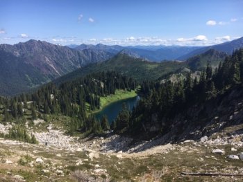
The next day we day hiked over to Doelle. There are many social trails, but follow the trail sign and cross the outlet stream and head up. You will see another sign indicating the main trail. It goes up - sometimes steeply - with increasingly good views including a bit of Daniel and Hinman. When you reach the saddle between Chain and Doelle Lakes, the views are phenomenal. We could see over toward Grace Lakes, Frosty Pass area, Glacier Peak, Sloan, Baker etc. It was ridge upon ridge. Take the better trail to the right - the one to the left is sketchy. Also to the left appeared to be a bootpath toward Chain Peak for scramblers. The main trail to right goes down to the first/bigger lake gently and safely. We stopped at a ledge just down from the pass and overlooked both lakes. We went down about 500 feet to the first lake. The camping is basically, bushwhack a bit down to that end of lake or continue to far end of lake where there are established sites and a backcountry toilet. If you are seeking to go to Frosty Pass, you will need routefinding skills as trail peters out.
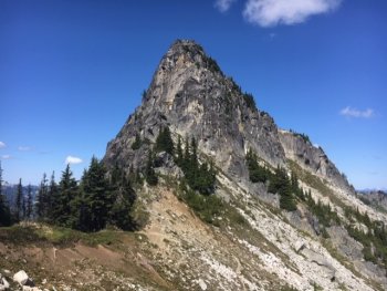
There has been recent trail work so blowdowns were minimal, but trail between Josephine and turnoff to Chain Lakes had brushy areas - not super bad. No problems between Chain and Doelle. If you wish to scramble up Bull's Tooth, there is a bootpath from the upper Chain Lake or you can leave main trail in a couple of spots. Stay left of forest section. Look for reports from scramblers. It is a major boulder hop with sections of exposure and loose scree near the top. Dave's GPS is from where they decided to leave the main trail on the return from Doelle Lakes. Fantastic views!!
Dave's GPS Track